


Video content: Satellite video showing images from the recent earthquake in Indonesia.
FACT:
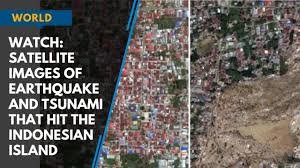
The video shared in the post shows a small earthquake and heavy rain that happened in Indonesia on September 28, 2018.
Sutopo Purwo Nugroho, who works at the Indonesian National Disaster Relief Agency (BNPB), tweeted on October 6, 2018, describing the video as an image of water during an earthquake in an Indonesian city.

Sutopo Purwo Nugroho said this video is from images recorded by the WorldView satellite during the earthquake of September 28, 2018.
This video does not show footage from the recent earthquake in Indonesia.
Therefore, the message is an image finder for the screenshot of the video, and a similar situation was found in an article on the news site “CNN” on October 1, 2018. CNN reported this with satellite images showing before and after images of cities destroyed by the Indonesian earthquake and tsunami on September 28, 2018, reporting the same thing, while many news websites shared the same image in October 2018. done.
You can find it here and here. Looking for other places on the Internet where this video is becoming a hot topic, many social media users in 2018 shared this video and said that it is a recent video made using satellite images showing water during the earthquake in Indonesia.
Several news sites reported that Sutopo Purwo Nugroho, director of media and public relations at Indonesia’s National Disaster Management Bureau (BNPB) first shared the leaked video.
The Instagram post of Sutopo Purwo Nugroho in this article is no longer available on his Instagram. To recap, a time-lapse video showing the 2018 earthquake in Indonesia and a satellite video of recent earthquakes in Indonesia are shared.


